Our politics are shaped by ancient maps
Oct 11, 2022 · 2 mins read
0
Share
Modern politics are the product of many things. But staggeringly, our society is largely shaped by history and geography in more ways than we realize:
Save
Share

Take this map of France in 1154 with the possessions of the King of England (technically he was also a vassal to the King of France) in red. In blue the possessions and vassals of the King of France
Save
Share

Now contrast it with where British citizens reside in France (the larger circle the larger the British population, the redder the higher the share of Brits in this area).
The Brits have settled hundreds years after in formerly "English" territories
Save
Share

These very same territories have also largely backed Emmanuel Macron in the first round of latest French presidential election over Marine Le Pen.
Save
Share
Zooming in on Paris, look at the districts that voted for Macron in yellow vs those that backed the far-left candidate Jean-Luc Mélenchon in red

Save
Share
Those eastern districts have been left-wing bastions for decades!
Here's map of the Commune of Paris in 1871, a famous left-wing revolution. The vast majority of its barricades (diamonds on the map) where in the east.

Save
Share
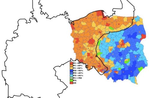
Poland boasts the most famous politically relevant old map : The partitions between Prussia, Russia & Austria are still visible in recent elections, with Russo-Austrian territories markedly more conservative. (2020 election with the old Austro-Prusso-Russian borders overlaid).

Save
Share
The old Prussian territories are markedly more centrist/liberal (orange) than the former Russian and Austrian lands who vote for the right (blue). 2007 election with the German empire overlaid on top.

That's all for now, subscribe if you want more content like this!
Save
Share
0